Watershed conditions
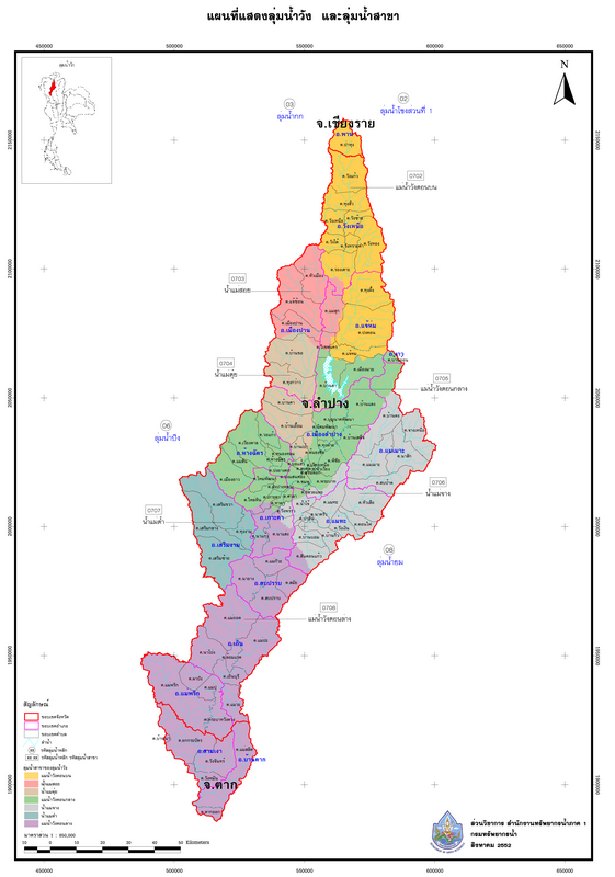
Wang River Basin It is the 7th of 25 major river basins in the country. Originating from the Phi Pan Nam mountain range, specifically in the Doi Luang area of Ban Pa Hung, Phan District, Chiang Rai Province, it flows through a valley into the plains of Lampang city and joins the Ping River downstream of the Bhumibol Dam at Ban Pak Kwang, Tak Ok Subdistrict, Ban Tak District, Tak Province. The basin covers an area of approximately 10,791 square kilometers, encompassing two provinces: Lampang and Tak, with a length of approximately 460 kilometers.
Subbasin division
The Wang River basin is divided into seven tributaries: the Upper Wang River basin, the Mae Suai River basin, the Mae Tui River basin, the Middle Wang River basin, the Mae Chang River basin, the Mae Tam River basin, and the Lower Wang River basin.
map
Watershed scope / Water resource development project / Small-scale water sources
Personnel
Wang River Basin Coordination and Management Division / River Basin Sub-committee / River Basin Working Group
Network
Existing network, youth network, new network, strong network.
For more information, please inquire.
Office location 2nd Floor, Regional Water Resources Office 1, 555 Moo 15, Bo Haew Subdistrict, Mueang District, Lampang Province 52100
Telephone number: 0 5421 8602 ext. 119 Fax: 0 5422 2938
e-mail : wungbasin07@live.com